Yarawindah Brook
Yarawindah Brook
PGE-Ni-Cu
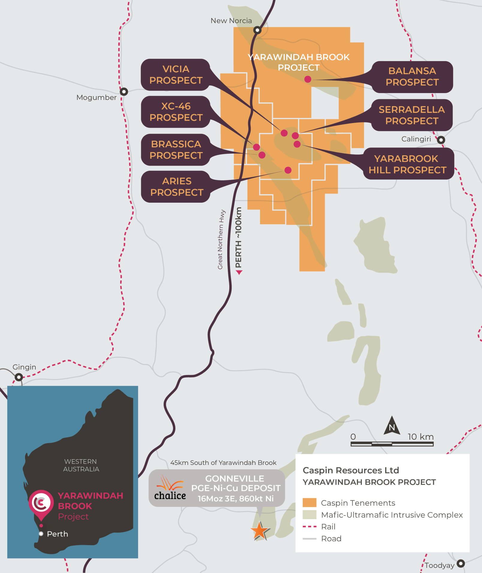
The Yarawindah Brook Project is located ~100km northeast of Perth, in the emerging PGE-Ni-Cu sulphide West Yilgarn province. The Project comprises a significant ground position of over 400km2, approximately 40km north from Chalice Mining’s discovery of the high-grade Gonneville PGE-Ni-Cu deposit.
Project Highlights
- Exciting new PGE-Ni-Cu frontier driven by the success of Chalice Mining at the neighbouring Julimar Project.
- Large landholding in the region (>400km) and an early mover into the district.
- Contains the Serradella Prospect, a significant PGE-Ni-Cu discovery with large-scale potential.
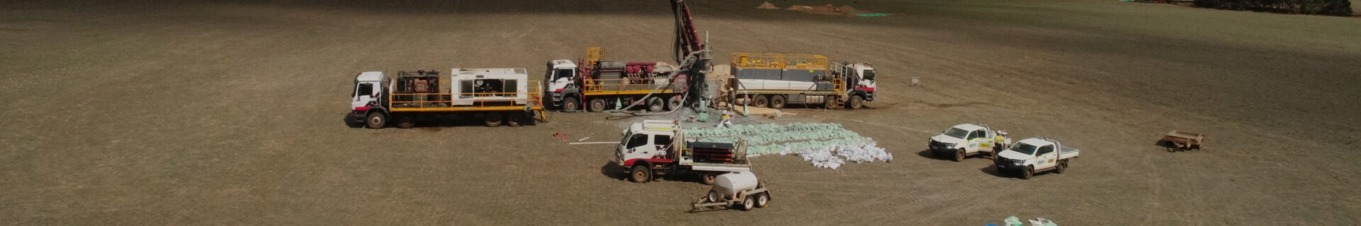
- Extensive exploration programs underway, testing near-surface resource potential.
The New Norcia region is deeply weathered, with little fresh rock outcrop and extensively covered by cultivated farmland. Despite the presence of known Ni-Cu occurrences, discovered in the 1970s, most historical exploration has focused on surficial bauxite deposits. As a result, there is limited deeper, bedrock drilling and the geology is poorly understood.
Yarabrook Intrusion
The Company has identified a large mafic-ultramafic body, known as the Yarabrook Intrusion, in the central part of the project, striking over approximately 4km and dipping gently to the northeast. Deep drilling by Caspin has shown the intrusion to be at least 1,000m thick. The Company has made a significant discovery of PGEs, nickel and copper at the Serradella Prospect, at the northern margin of the intrusion. Within the prospect are two recognised styles of mineralisation:
- Peridotite Lode – characterised by platinum and rhodium dominant mineralisation with lesser palladium. Examples include YARC0036 – 17m @ 0.39g/t Pd, 1.73g/t Pt, 0.20g/t Rh, 0.01g/t Au. The host unit to this lode is geologically distinct, with low chrome values compared to other peridotites at the prospect.
- Pyroxenite Lode – characterised by palladium dominant mineralisation with lesser platinum and rhodium. Examples include YARCD0025 – 12.1m @ 1.45g/t Pd, 0.54g/t Pt, 0.06g/t Rh, 0.08g/t Au. This lode is also hosted by a distinctive unit with relatively low calcium values compared to other pyroxenites in the prospect.
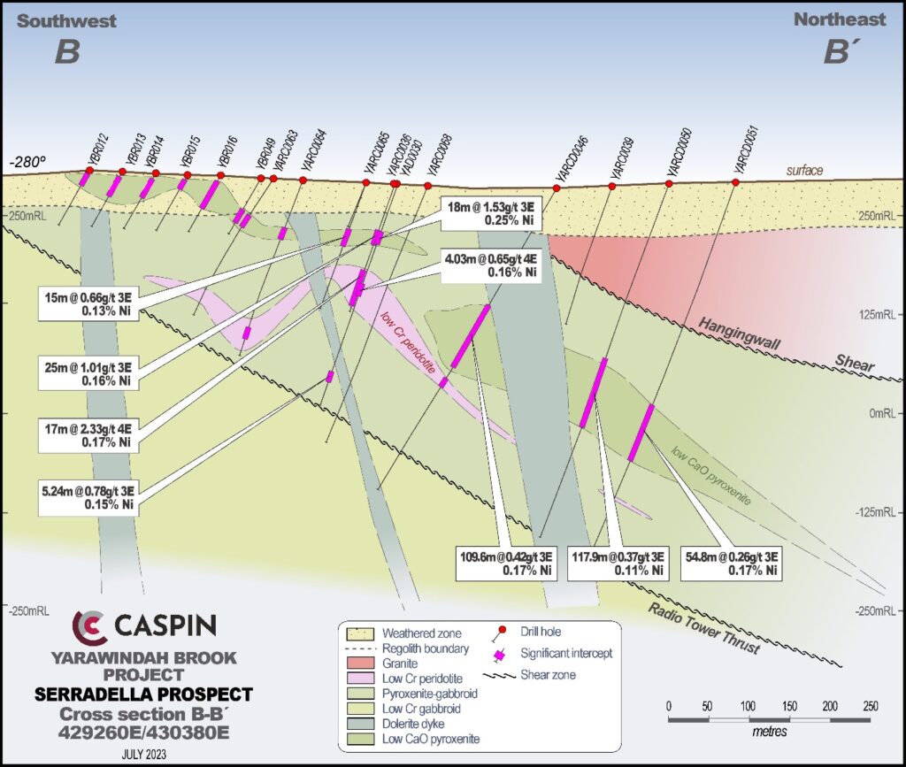
The Peridotite Lode host unit forms a distinctive dome shape within the stratigraphy which may represent a primary emplacement channel (noting that the intrusion is over-turned). Mineralisation is concentrated on the east side of the dome in a sub-vertical orientation, striking in a north-south direction through the intrusion.
The Pyroxenite Lode is the most extensive zone of mineralisation and whilst locally it can be high-grade, it also serves as the host for significant thicknesses of low to moderate-grade palladium mineralisation. This body occurs in the structurally upper part of the intrusion, close to the surface, and continues down-dip beyond the extent of current drilling. The Company has previously contemplated that the tenor of this mineralisation may increase at depth towards the basal contact of the intrusion.
Mineralisation in both lodes remain open with the Peridotite Lode a priority because of its higher grades and proximity of mineralisation close to surface.
Regional Exploration
The Company has identified many other prospects throughout the project.
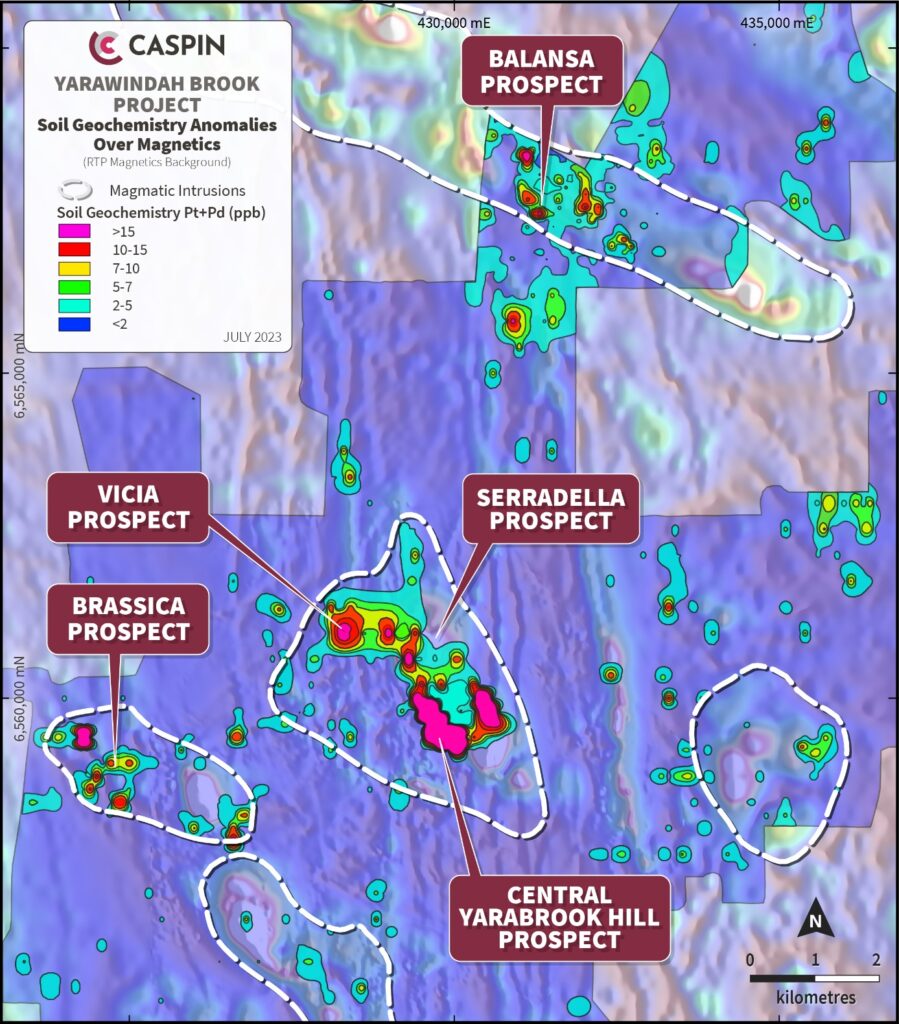
The Vicia Prospect lies immediately west of Serradella and possibly represents a thrust slice of the same broad mineralised system from beneath the Radio Tower Fault, which was initially considered to host only barren gabbroic rocks. Mineralisation occurs over a strike length of at least 600m with at least two PGE-mineralised lenses. Drill hole YARC0030 returned a best result of 32m @ 0.48g/t 3E from 53m including 4m @ 1.12g/t 3E from 81m.
Recent soil geochemistry programs have identified a new coincident PGE-Ni-Cu anomaly, named the ‘Balansa Prospect’, approximately 7km to the north of Serradella. The Balansa anomaly is approximately 1,000m in diameter and is coincident with a strong magnetic feature, interpreted to represent mafic or ultramafic intrusive rocks. Importantly, not all of the magnetic feature is anomalous, thereby increasing the likelihood that the anomaly represents basement mineralisation rather than background lithology.
Lithium Prospectivity
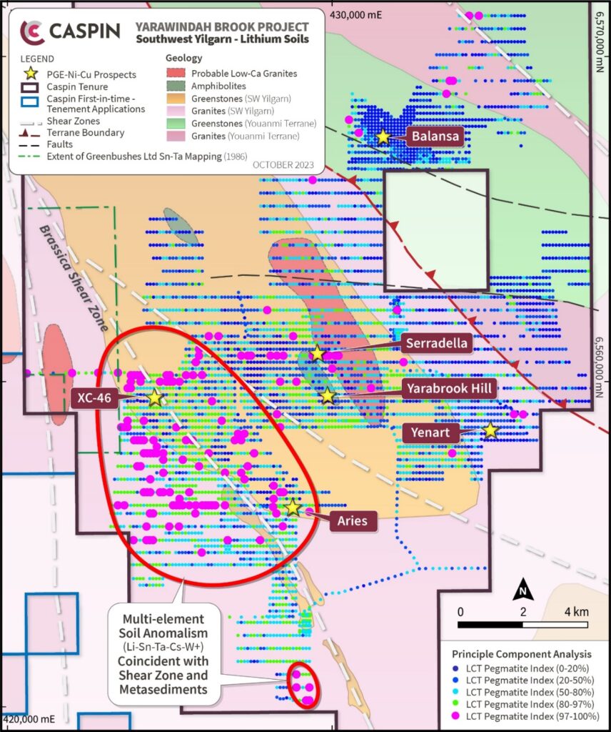
The world’s largest LCT pegmatite deposit is the Greenbushes mine (360Mt @ 1.5% LiO2), just three hours south of Perth. The Yarawindah Brook Project sits within the same geological terrane as Greenbushes, the Southwest Yilgarn, which is defined by Neoarchean greenstone packages intruded by felsic granitic rocks.
Limited historical exploration in the area has highlighted the local presence of suitable source granites containing metals such as lithium, tin and tantalum. These granites are bound by numerous northwest trending shear zones and later east-west striking faults which may provide fluid pathways for mineralisation to be deposited in the surrounding greenstone package.
Caspin has collected over 5,000 soils samples across the Yarawindah Brook Project with initial analysis highlighting a strong LCT pegmatite elemental association, especially to the west of the Brassica Shear Zone. The Company has created a “LCT pegmatite index” by combining important lithium pathfinder elements together. Peak individual soil values include 80ppm Li, 61ppm Nb, 24ppm Sn, 12ppm Ta and 102ppm W, representing two to ten times background levels. Soil geochemistry is supplemented with extensive geophysical, radiometric and remote sensing datasets.
Next Steps
For further information on the Yarawindah Brook Project please view our latest Announcements: